Going-To-The-Sun Road(trip)
The Going-to-the-Sun Road is Glacier National Park's only route directly connecting the east and west sides. Starting at East Glacier, my friends and I followed this 50-mile, paved, two-lane marvel, using the GuideAlong app to discover key stops without planning major hikes.
Many stops are worth taking throughout the day's drive but can get overwhelming quickly, especially during peak seasons. Before driving the Going-To-The-Sun Road, a permit is required and they are limited to help relieve congestion on the highway that bisects the park east and west. Permits for vehicle registration can be purchased on Recreation.gov.
Saint Mary, East Entrance
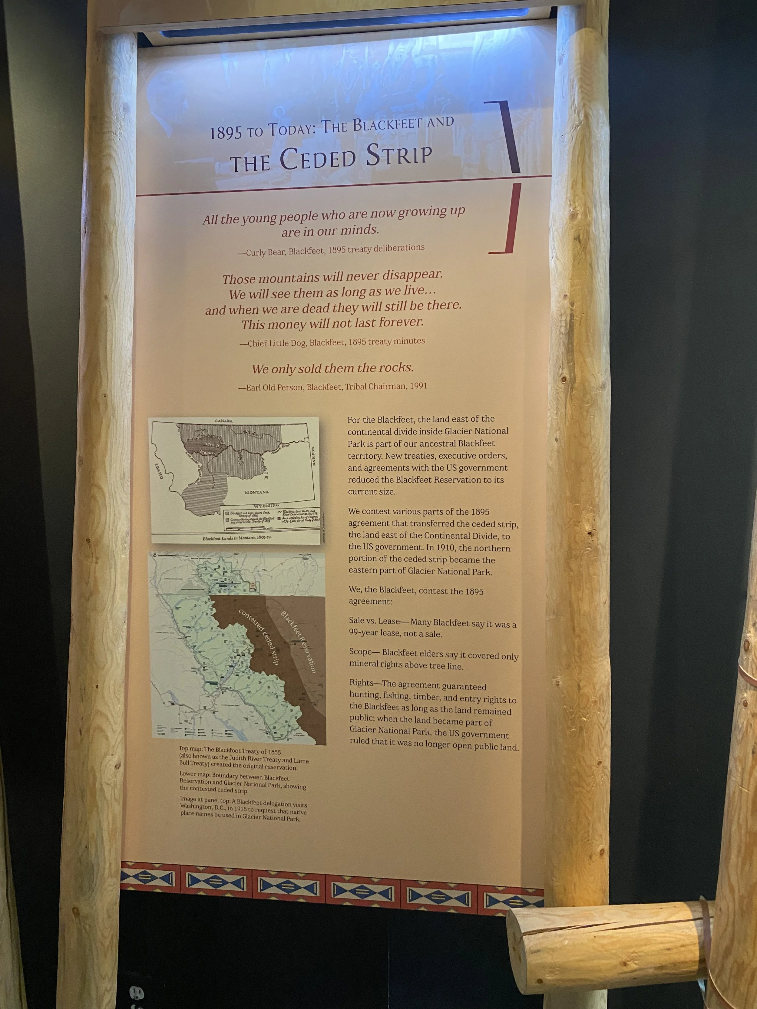
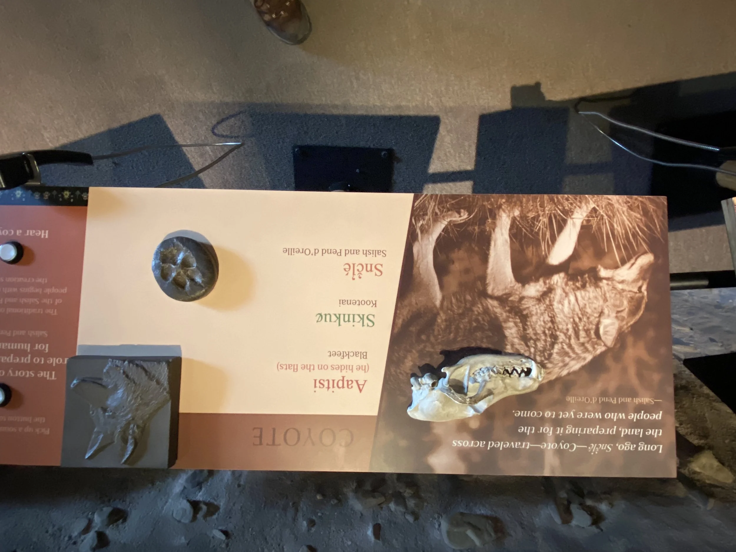
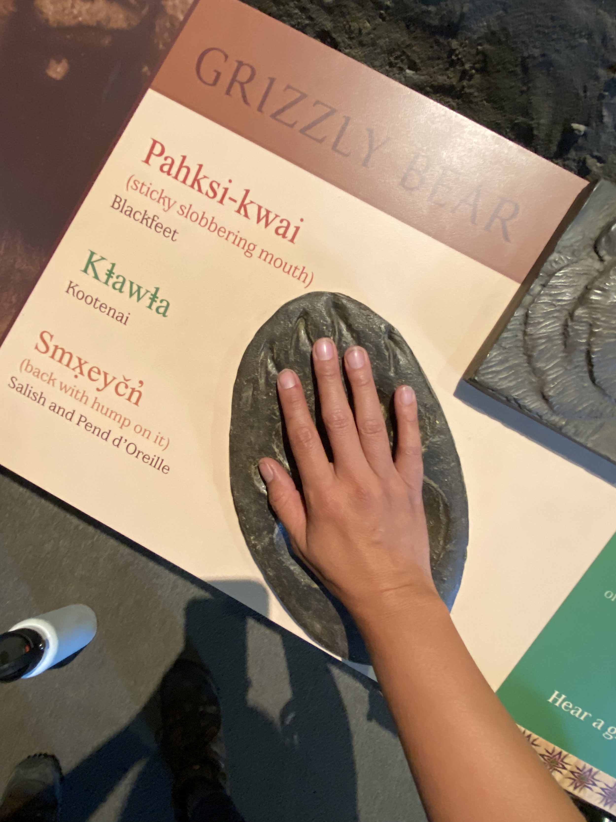
Starting from East Glacier, we spent some time inside the St. Mary Visitor Center as we walked through Native American history significant to this area. This landscape was shared between peoples of the Blackfeet, Kootenai, and Salish, and Pend d'Oreille for centuries before the arrival of Europeans. While most of their homes and history have been wiped away, the landscape of Glacier is a product of a mutual desire to preserve the area in its pristine condition. As access expands, limitations have become necessary to maintain the landscape and the history that makes this place so special. What I especially loved about this small museum were the lessons of connection to the land and animals. From the wolf to the elk, coyote, and grizzly bear, the animals are seen as "the original managers of [the] land, not people" (Rusty Tatsey, Blackfeet). There is also the ancient spiritual and material significance of the areas that possess place names, making Glacier the "Backbone of the World."
After filling our minds and hearts with a deeper appreciation for where we have been and were about to go, we made our way to the Going-To-The-Sun Road, but not before incorporating our tradition of taking our photo with the Glacier National Park sign.
Glacier National Park, East Entrance, St. Mary, 2023.
Stop 1: Rising Sun
Only 6 miles west of the Saint Mary entrance, there are plenty of hiking and boating activities around the lake. Rising Sun is the official entrance into the great mountains of Glacier National Park coming from the east. We only passed by, but the views were otherworldly–I’d never seen mountains of this magnitude. Rising Sun has campgrounds, showers, a restaurant, and a camp store.
Approaching Rising Sun on the Going-To-The-Sun Road, 2023.
Stop 2: Wild Goose Island
Many hikes are available around St. Mary Lake, including the summit of Red Eagle Peak, but I saved that on my “next time” list. As suggested by the GuideAlong app, we pulled over at the Wild Goose Island Lookout with gorgeous panoramic views of surrounding mountain peaks draped around St. Mary Lake. Wild Goose Island is the centerpiece of the spectacular view and one of the most photographed places in the world! Famous for its feature in Stanley Kubrik’s iconic horror film, The Shining, the tiny island rises only 14 feet from the surface of St. Mary Lake with Heavy Runner Mountain in the distance.
Wild Goose Island, 2023.
Fun geology fact: It is still a mystery why the island exists. Geologists are left perplexed given that thousands of years ago, a massive valley glacier almost entirely carved out the valley where Saint Mary Lake rests. The lake floor is hundreds of feet below the island’s surface, yet this narrow piece of earth survived its evolution.
Stop 3: Jackson Glacier Overlook
Jackson Glacier Overlook, 2023
Between Wild Goose Island and Jackson Glacier Overlook, a plethora of stops are filled with overlooks, hikes, and waterfalls.
Like Pokemon, it’s tough to catch ‘em all, but here’s a quick list of short stops you can take:
Sun Point: close-up view of St. Mary Lake and a historic location where the Going-To-The-Sun Chalet once stood. More info on Galcier’s Chalets here. This location is also home to the Sun Point Nature Trail (2.4 miles in and out) where you’ll come across Baring Falls and towering mountains.
Sunrift Gorge: only a 75-foot walk, the Sunrift Gorge was cut by Baring Creek which originates near Sexton Glacier (rested on the east face of Going-To-The-Sun Mountain)
St. Mary Falls/ Virginia Falls: Both falls can be viewed while on St. Mary Falls/ Virginia Falls trailhead just less than a half mile from Sunrift Gorge, and it’s only a 1.7-mile hike (one way).
Jackson Glacier, 2023.
With my 100-400mm telephoto lens, I zoomed in on the iconic Jackson Glacier. It’s crazy to think this natural monument will completely melt away.
The combination of rapid climate change and summer has left much of Mt. Jackson bare, however, the pullout to view this world-famous glacier is worth the stop. Jackson Glacier is known to be part of the largest grouping of glaciers called the Blackfoot-Jackson Glacial Complex. This pullout is also the start to the trailhead where hikers can hike to Gunsight Pass and beyond–a popular day hike and overnight backpacking hike in the park. With the constant change in scenery from Hurricane Hilary’s heavy clouds, I took a moment to capture this moment with my travel comrades.
Jackson Glacier Overlook, 2023.
Looking across the street, I noticed the sun gleaming on this small mountain, however, I am unsure of its name or if it even has one. I found every structure to be fascinating, even the nameless.
Unknown mountain, 2023.
Stop 4: Siyeh Bend
The prominent Siyeh Bend is part of a sharp curve just 3 miles east of Logan’s Pass and the start to trailheads Siyeh Pass and Piegan Pass–also very popular hikes in the middle of the park’s paradise. The bend also provides an adjacent view of Heavy Runner Mountain. The transition between higher-elevation subalpine vegetation and the forests of the east side becomes more apparent in this area.
While the pullout provides a stunning view of the bend, across the street is Apikuni Falls that stretches 100 feet from a rocky outcropping through meadow and forest.
As my friend soaked in the stunning views of the bend, I turned around after capturing Apikuni Falls and called out her name. As she turned to look my way, she saw my lens pointed in her direction and quickly smiled. That’s all I needed–couldn’t have been a more perfect shot of her in her element.
Across the bend, you can see Sexton Glacier, located in a cirque north of Going-to-the-Sun Mountain and on the southeast slope of Matahpi Peak. Stretching across 68 acres, the glacier is one of the last glaciers in the park and has lost approximately 25% of its area between 1966 and 2015.
Sexton Glacier, 2023.
I am unsure of the name of the waterfall that is fed by Sexton Glacier, but I zoomed in with my 100-400mm for a closer perspective.
Stop 5: Logan Pass
As one of the most popular stops in Glacier National Park, the Logan Pass Visitor Center is home to the start of two famous hikes in the park: The Hidden Lake Overlook and the Highline Trail. The trails are among the top things to do in Glacier National Park and are fairly busy. Shuttles are offered to beat the traffic. Otherwise, you might find yourself waiting hours for a parking spot. Since we were approaching lung hours, there was no way we’d wait for a parking spot, so we kept moving–but it’s also part of my “next time” list.
Fun Fact: The Continental Divide is at Logan Pass and is the highest elevation point reachable by vehicle at 6,646 feet above sea level.
Stop 6: Oberlin Bend
Oberlin Bend, 2023.
Oberlin is immediately west of Logan Pass, just below the cascading waterfalls of Mount Oberlin. The pullout leads to an easily accessible boardwalk with breathtaking views of the hanging valley and the Going-To-The-Sun Road as it winds west of the Continental Divide. This area is known as an ideal place to see mountain goats, although we were not so fortunate, which could have been due to the low-bearing clouds. No complaints here–the view was one-of-a-kind!
Oberlin Bend, 2023.
Just before we made our way back to the car, we stopped to enjoy Oberlin Falls. Of course, I had to set up my tripod for a group photo. Here, I had some time to apply my NiSi filter for a quick long exposure to enhance the movement of the falls.
Stop 7: Big Bend
As a native Texan, I’m used to thinking of our one of two National Parks in West Texas, however, Glacier National Park’s Big Bend is full of dramatic vistas of the Lake McDonald Valley and the high peaks of Mount Canon, Oberlin, and Heaven’s Peak. The pullout is rather large with plenty of parking for a break from driving and hikers alike. After a short walk from the pullout, you’ll become blanketed in a field of Montana’s fireweed wildflowers during late summer.
Mount Cannon, Big Bend, 2023.
After a sweet couple asked me to take a few pictures of them, they offered to capture quite a few photos of me!
Fun historical fact: A concept of wilderness in the U.S. is one that is codified in The Wilderness Act of 1964 as “an area where the earth and its community of life are untrammeled by man.” Official wilderness requires Congressional legislation, and while most of Glacier National Park was recommended as wilderness to Congress in 1974, a bill has yet to be enacted. I like to think of the wilderness as a place where humans can examine their relationship with the natural world.
Stop 8: Weeping Wall and Haystack Falls
While it is not an official stop/ pullout, you cannot miss Weeping Wall as you drive through its waterfall. The running water is fed by seasonal runoff from the melting snow and ice, and spring is known to gush onto the road. If you’re lucky, you’ll find yourself driving through a small rainbow from the constant water flow. Neighboring Weeping Wall is Haystack Falls, where there is a small turnout if you want to snag a photo. Thankfully, I was able to appreciate the 490-foot waterfall from the Bird Woman Falls pullout with my 100-400mm lens.
Stop 9: Bird Woman Falls
Bird Woman Falls, 2023.
Driving deeper into the west end of Glacier National Park, Bird Woman Falls towers 560 feet and is one of the most popular waterfall stops. The waterfall cascades down Clements Mountain and is fed by a retired glacier, now a permanent snow field. From the outlook, the triad of Mount Oberlin, Clements Mountain, and Cannon Mountain dominates the landscape, however, if you have a strong telephoto lens or binoculars, you can zoom in on the dramatic waterfall.
Fun geology fact: Directly below the permanent snow field is a strong example of a “hanging canyon” that was sculpted by glaciation that occurred roughly 10,000 years ago. It was halted by another glacier during the same ice age and is now where Bird Woman Falls is located.
Overlooking Bird Woman Falls, 2023.
Stop 10: The Loop
It’s no wonder why Going-To-The-Sun Road is considered an engineering marvel, and The Loop is evidence of overcoming the complexities of building this iconic highway within the alpines of Montana. The Loop is the only switchback along the western side of Going-To-The-Sun Road and marks the transition into the narrow, carved-into-the-mountainside portion of the road. Restrooms, a shuttle stop, and limited parking are available for hikers who wish to venture The Loop Trail (4.2 miles one way and 2600 feet) to reach the Granite Park Chalet and join the Highline Trail.
Stop 11: West Tunnel
Not a stop, but get your phones ready to record your journey through this short tunnel. Considered another engineering marvel, laborers between 1926 and 1927 constructed the tunnel that takes vehicles through a cliff. East of the tunnel are very limited pullouts where you can walk into the tunnel and stand within two observation windows to view Heavens Peak and McDonald Creek.
West Tunnel, 2023.
Stop 12: Trail of the Cedars
Prepare to be awe-struck by towering old-growth trees on this dense forest-like trail less than a mile long. The trail is considered a “must-see” location and it has an accessible boardwalk for everyone to enjoy the trail. Unfortunately, I lost the footage on my phone, but gorgeous images can be seen here. However, I did capture a photograph of the beautifully turquoise waters of Avalanche Creek where we saw many families enjoying a plunge into the cold creek.
Avalanche Creek, Trail of the Cedars, 2023.
Stop 13: Apgar Village
Known as the first major stop of the west entrance, Apgar Village is a hub for the west side of Glacier National Park. Here, you’ll get classic views of Lake McDonald and can experience restaurants, motels, cabins, gift shops, general stores, a visitor center, and a campground and backcountry ranger station. It’s a popular visiting ground, full of people enjoying hiking and biking trails, and plenty of water activities.
After making our final stop in Apgar Village, we headed for our campsite in the Fish Creek Campground. It is the second largest campground in the park that takes reservations next to Apgar Campground. Surrounded by trees and winding elevations, our campsite was provided with shade and decent privacy. Some campsites reside on the shore of Lake McDonald. However, ours was nestled at an incline of the winding hills. Just as we arrived to set up camp, a park ranger stopped by while riding his bike to inform us a rather large storm was heading our way and to prepare for possible hail and flash flooding. Thankfully, we pitched our tent just in time as the heavy rains rolled in just a few hours later.
Pro tip: If camping at an incline, direct your tent opening facing downhill and create a small ditch for water runoff. This makes access in-and-out much easier and less messy inside of your tent.
Once the storm quickly passed, we enjoyed our dinner among the trees (some snapped in the storm, but thankfully, none fell on us) before hiking to the Lake McDonald shore for a beautifully dramatic sunset. Despite the Going-To-The-Sun Road being a 50-mile paved highway, the many stops we made depleted our energy by the end of our day-long journey–worth it.
I seldom used my NiSi filter kit throughout our drive, however, this was the perfect opportunity to switch out multiple lenses and filters as the sun and clouds danced throughout the mountains draped behind Lake McDonald.


It was a perfect ending to a perfect travel day along the Going-To-The-Sun Road with a breathtaking sunset as we skipped rocks on the calming lake and relaxed on the shore.
If you’d like to own one of these photographs, click or tap on the eligible images to go to my print shop.
Every purchase allows me to continue to do what I love as an exploring artist. Thank you!


