
Hiking the Highest Elevation Point in Texas
In Summer 2022, my best friend, Katie, and I made a plan to travel across West Texas and New Mexico to visit four national parks within seven days. I’m so glad we turned our dreams into reality! There is no way to provide all experience within one post, so I’ll have to save one post per experience. For the first post about my Chihuahua Desert adventures, I’ll bring y’all with me up the 8,751 ft summit of Guadalupe Mountain. This wasn’t our first stop, but it was the peak of our plan for this trip. The Guadalupe Summit is known for being the highest elevation point in Texas and is guaranteed to be a great adventure. Considering neither of us had ever embarked on an adventure at this level, we made plans to start training the moment we decided to hike this desert mountain.
My training process:
Although an intimidating number, I was appreciative of my training for this moment. For eight weeks, I prepared my body with a rigorous workout and diet regiment to optimize my stamina and endurance for this grueling hike. Of the eight weeks, I spent two hours a day, six days a week in the gym: 30 minutes of fast-paced walking at a three-degree incline on the treadmill, one hour of designated weight training, then another 30 minutes of fast-paced walking at a 10-12 degree incline on the treadmill.
I used to run cross country as a teenager, but I do my best to stay away from it; walking at a high incline on the treadmill more often will allow me to keep a steady heart rate of 150-160 bpm. As I felt more confident about maintaining a steady heart rate, I added a 12-pound weighted vest to further prepare me for what I’d need to carry on my mountain hike.
I can’t stress the importance of maintaining a beneficial diet during the physical training process. While I can’t suggest what is best for others, I made it a point to pay attention to what my body needed throughout my journey. What I can suggest is ensuring your water intake increases with your training. I drank at least one gallon of water daily to maintain my hydration levels. Additionally, I eliminated most carbs from my meals and increased my protein intake. While not my intention, I was the leanest I’d ever been.
Now, let’s hike!
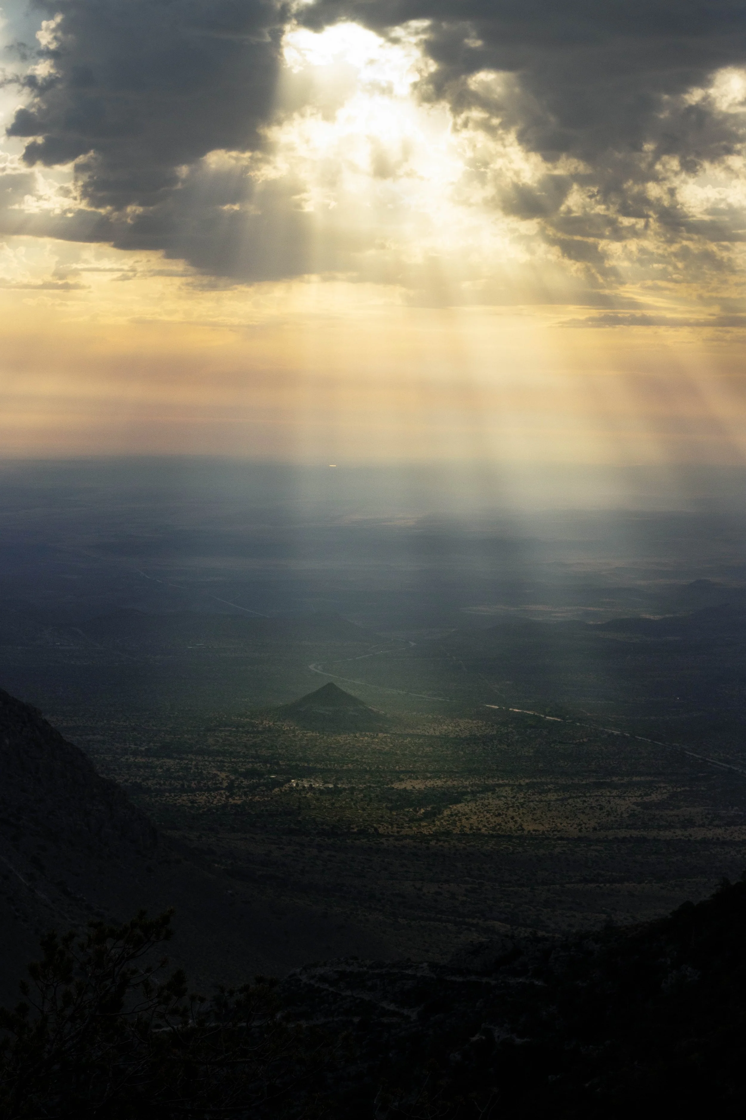
Katie and I got a somewhat early start around 4 am. I say somewhat because some hikers began their ascent 2-4 hours earlier. The end of May falls within the off-season and I now understand why. The Chihuahuan Desert is full of high winds, especially at the Guadalupe Mountains National Park, and we were expecting winds up to 70mph by 2 pm; so yeah, we wanted to descend around noon—just in time to have some lunch at the peak. Consequently, the early mornings were cold and we started the trail bundled up.


Naturally, as we continued our ascent, our bodies warmed up and we removed one layer at a time. Originally, we wanted to catch the beautiful Texas sunrise at the summit, but getting up at 4 am just wasn’t early enough. We settled on a few boulders and waited to watch the rays beam through the clouds. While taking advantage of our short rest, we had a quick snack from our bags with a CLIF bar to load up on some protein. With each bite, we remained quiet and present to enjoy the peaceful view. Once the sun broke through, I pulled out my camera to snag some images.


What to pack:
Above all, be sure to pack plenty of water. When on major hikes, you want to ensure your water intake is a minimum of one gallon a day. Before our hike, we each drank a substantial amount of water. I drank a half gallon. About 30 minutes before we completed our descent I had run out of my supply.
Although in short supply, there is wildlife roaming around the Guadalupe Mountains, so packing sealed snacks is vital to a safe hike. We packed a couple of CLIF bars and sandwiches for lunch at the peak. To be safe, we packed a couple of hydration packs if at any point we felt water wasn’t enough. There are many options available, but I personally like NUUN and Liquid IV.

As great as our view of the sunrise was, we still had a long way to go. We kept hiking along the Guadalupe Peak trailhead and documented only a few moments going up.


The trailhead up was moderate, not as harsh as I expected. The trailhead has some steep and often winding switchbacks. Incorporating walking sticks can be highly beneficial for better assistance. After a while, I could feel the weight of my food and water supplies, and my camera equipment. Given this was my first hard mountain trek, I didn’t want to add too much weight from my camera gear—I just my nifty-fifty camera body. Remember, a pound of water weighs roughly eight pounds. While we only packed small protein snacks and sandwiches, we needed room in our bags to take off layers as the sun made its appearance.


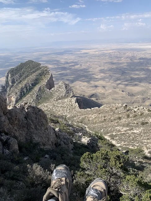
During one of our breaks to take off another layer, I was able to snag a shot of the rolling mountains of New Mexico. Guadalupe Mountains National Park is right on the border of Texas, allowing us to grasp a great view of the neighboring state.

But it was the view at the summit that made all our hard work worth it! We soaked it up, had lunch, and took a much-needed break before the winds started to pick up. The steel pyramid marker seen at the Guadalupe Peak was erected by American Airlines in 1958 to honor the route used for stagecoach travel over 100 years ago, the Butterfield Overland Mail trail.
Butterfield Overland Mail (officially the Overland Mail Company) was a stagecoach service in the United States operating from 1858 to 1861 and the marker was erected to honor those that carried passengers and U.S. Mail from two eastern termini: Memphis, Tennessee, and St. Louis, Missouri, to San Francisco, California. I had no idea this marker was here, but found this information interesting after getting back home to do my research.


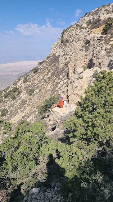
After lunch, we made our descent to base camp at 5,000 feet. You’d think going down is easier than going up, but those steep drops and switchbacks impact your knees. On the way down, we went at a slower pace and came across a few sights we missed on our way up. One view tempted me to sit on a ledge and appreciate the other well-known peak of El Capitan. Katie caught me sitting at the edge of what looks like a very dangerous cliff-side—and that could’ve very well been the case. I’ll let you be the judge.


Once we reached the end of the trail loop, we had taken off most of the layers we started with, and only had 32oz of water left out of the approximate 3 gallons we packed. We were hot and happy to be back to on base camp. If you’ve ever been on a hike with me, you know how crazy I can get; I was on a natural high and felt like I needed more. Unfortunately, Katie wasn’t up to join me and my phone died, so I informed her of my route and told her to notify the park rangers if I didn’t return by midnight. More on my solo trip to Devil’s Hall here.


If you’d like to own one of these images, click or tap on the image eligible for purchase to go straight to my print shop.
Disclosure: As an Amazon Associate, I earn commission from qualifying purchases.